I created a very simple bash function for revealing it's latitude and longitude, copying them, and then opening it in Google Maps. And of course, I then made a quick Alfred Workflow for it.
Bash Function
Add this to your ~/.bash_functions (or wherever you keep them):
# Run on photos with embedded geo-data to get the coordinates and open it in a map
whereisthis() {
lat=$(mdls -raw -name kMDItemLatitude "$1")
if [ "$lat" != "(null)" ]; then
long=$(mdls -raw -name kMDItemLongitude "$1")
echo -n $lat,$long | pbcopy
echo $lat,$long copied
open https://www.google.com/maps?q=$lat,$long
else
echo "No Geo-Data Available"
fi
}
If you copy that code above and then run pbpaste >> ~/.bash_functions it will add at the bottom there for you.
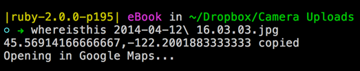
Then, you can run whereisthis photo.jpg to find out where the photo was taken.
Alfred Workflow
- Install the Workflow by downloading it.
- Just select any file and go the Actions menu and select "Where Was This Photo Taken?"
- Your browser will open to a Google Maps page at the location.
I thought about restricting it to only JPGs, but then realized movies could get geo-tagged, and actually any file could get a location assigned, so I left the file type restriction un-set.
Hope this helps some of you out there!